Thursday 24 September 2015

Island 296 - Gores Island, Strangford Lough, Northern Ireland

Gores Island is a tidal island linked to Castle Island at the south east end of Strangford Lough by a gravel causeway, which is covered at high tide.  The owners seem to have forgotten to put up the Private signs or maybe they can't do this, as the track to it from the road at Castle Island is also covered at high tide.  I visited an hour or two before high tide and the causeway was still crossable.  I didn't stay long, as the tide was coming in and I was concerned I might be trespassing.  In the unlikely event that the owner of Gores Island ever reads this post, I only ventured a few metres from the island end of the causeway and didn't enter any fields.  

Gores Island is just over a kilometre from east to west and about 800 metres from north to south at its widest point.  It is used for grazing.  There were cows in the field nearest the causeway when I visited. I don't think the island is inhabited.


 Grazing fields on Gores Island

 Tidal track that runs along the south coast of Gores Island

 looking north up the west coast of Gores Island

 Castle Island from Gores Island

Gores Island from Castle Island

Island 295 - Castle Island, Strangford Lough, Northern Ireland

There are two Castle Islands in Strangford Lough.  The one to the north of Ringhaddy appears not to be accessible - more "private road" notices.  The one I visited is located a couple of miles north east of Downpatrick.  It is no longer a true island as where the water used to be on the south side of the island has largely silted up and turned into marshy land.  

You can drive along the road that runs along the south coast to a wildlife hide, as part of the island is a nature reserve. However there are notices along the road saying that you can't walk off the road and you can't see much from the car, due to the trees lining the road.  I followed the road right to the end to see if it was possible to access Hare Island but at the end of the beautifully surfaced road there is a roundabout and lots of "Private, Keep Out" notices at the entrance to the Quoile Yacht Club, which is protected by lots of barbed wire - not very welcoming!  From the hide you can apparently see waders, swans and ducks.  I didn't get out of the car - to be honest the island gave me the creeps.


 Entrance to Quoile Pondage Nature Reserve

North side of the causeway looking towards the mainland

Island 294 - Gibbs Island, Strangford Lough, Northern Ireland

Gibbs Island is connected to the south west shore of Strangford Lough by a pedestrian causeway and is accessible at all states of the tide.  It is owned by the National Trust and there is public access to it.  There is a small car park at the end of Island Road, which comes off the A22 Killyleagh Road a couple of miles south of Killyleagh.  It is a popular place for local dog walkers and there were several other people out for a walk on it when I visited on a Sunday afternoon in September.  It is a lovely spot but I suspect that its popularity might also be due to the lack of public access to many other areas in the vicinity.

There is one house at the northern end of the island.  The centre of the island is covered in mature trees: e.g. pines, oak, sycamore, hawthorn, elder and ash.  There is a perimeter path and also one across the top of the island.  The island is roughly oval in shape and is about 500 metres from north to south and 200 metres from east to west.  When I visited in early September 2015 thistles, buttercups, dandelions, birds foot trefoil and meadowsweet were in flower.  There were also plenty of nettles and brambles.

Causeway leading to Gibbs Island

There is no doubt by whom Gibbs Island is owned!

Looking towards the top of the island

Looking north towards the island's only house

Campfire site at the centre of Gibbs Island

Lone Tree

A place to rest and think at the south end of the island

Island 293 - Braddock Island, Strangford Lough, Northern Ireland

Braddock Island is a small tidal island with a house on it located 200 metres to the east of Whiterock Village on the eastern side of Strangford Lough.  Unusually there were no Private signs, apart from one on the short track leading to the shore, which could be avoided by walking along the beach.  I ventured across the gravel causeway at low tide and walked part of the way round the north side of the island on the outside of the wall surrounding the garden of the house.  

In the unlikely event that the owner of Braddock Island reads this post, I did not go anywhere near the house or enter the garden at any point.  I sat on a rock above the high tide level for the required 10 minutes, took a few photos and then made my way back to Whiterock.   There didn't appear to be anyone at home in the house on the island when I made my brief visit.


 Braddock Island from Whiterock

 Looking north towards Sketrick Island

 House from the shore

The only house on Braddock Island

Island 292 - Sketrick Island, Strangford Lough, Northern Ireland

Sketrick Island is linked to the western shore of Strangford Lough half a mile to the north of Whiterock by a causeway, which is accessible at all states of the tide.  The island is about 600 metres from east to west and 500 metres from north to south.  The public road ends at the island end of the causeway.  The island has a restaurant/bar called Daft Eddy's, which is adjacent to a coffee shop.  I only visited the coffee shop and their millionaire's shortbread was excellent.  I was there on a Sunday lunchtime and the car park was full, so Daft Eddy's is presumably very popular.

Sketrick Island also has a castle, which you can explore.  It is a tower house and was probably originally built in the mid 15th century, although the present building may date from the 16th century.  In the 16th century it was actively involved in warfare.  It was originally 4 stories high and it remained largely intact until half of it collapsed in a storm in 1896.

There is public access along a track round the northern shore of the island for a few hundred metres and then there is a permissive footpath up the hill.  I don't know if the footpath goes anywhere, as the field was full of cows, so I didn't venture across it.  I suspect you have to walk back the same way, as the track found the south side of the island is private.  There are quite a few houses marked on the map along it.

 Sketrick Castle 

 Causeway to the mainland from Sketrick Island

 Northern side of Sketrick Island

 Another private road

 Daft Eddy's Restaurant

 Island Coffee Shop

There is apparently an oyster farm on the island

Island 291 - Mahee Island, Strangford Lough, Northern Ireland

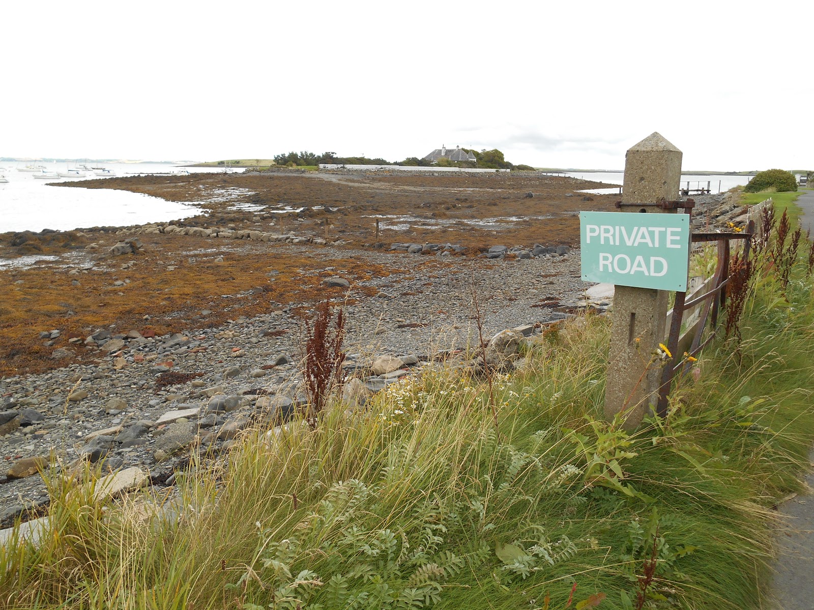
Mahee Island can be accessed by car via the neighbouring Island Reagh.  However you can only access the western end of the island as far as the site of the Nendrum Monastic Site.  The rest of the island is private.  Northern Ireland appears to have very few public footpaths and lots and lots of private, keep out notices.  There is a 9 hole golf course on the island, which was founded in 1930.

The island takes its name from St Machaoi who set up a monastery on the island in the 5th century.  The monastery consists of 3 concentric round dry stone walled enclosures. The central enclosure contains a ruined church and a sundial, the remains of a round tower and a graveyard. The middle enclosure has the remains of huts and workshops. It is the best example of a pre-Norman monastic site in Northern Ireland.  There is a small car park and a visitor centre which has various displays, models, artefacts, videos and most importantly a toilet. The site is not suitable for disabled access, as it is up a steep slope.  The views down Strangford Lough from the monastic site are stunning.  When I visited in September 2015 there was no admission charge.

Round Tower
This was originally 27 metres tall and was probably built in the 10th century. Its main purpose was to call the monks to prayer at designated times of the day.  Time was measured using a sundial, like the one shown below (I don't know how they measured it when the sun wasn't shining or during the hours of darkness).  A monk would ring a hand bell from the top of the tower.  The tower was also used as a treasury to store valuables and as place of refuge when the monastery was attacked.  There were originally around 65 round towers on monastic sites in Ireland. They are known in Irish as cloigtheach, which means "bell house".  This style of round tower is almost unique to Ireland.  There are also 2 in Scotland (at Abernethy and Brechin) and one at Peel on the Isle of Man.

Reconstructed sundial 

The nave of the chapel was built in the 10th century around the same time as the round tower but it probably replaced an earlier wooden church.  In the 13th century long after the monastery had ceased to function it was converted into a parish church and a chancel was added.  In the later Middle Ages the local congregation moved to the church on the mainland at Tullynakill and the church on Mahee Island became a ruin.  The site was rediscovered in 1844 by William Reeves, who later became the Bishop of Down and Connor came in search of the sites mentioned in a papal taxation record of 1306.  He realised he had found the site of Nendrum when he was shown the ruin of the round tower.  However the site remained overgrown and neglected until it was excavated 1922-24 by the Belfast Natural History and Philosophical Society led by HC Lawlor.  It has been care for by the Department of the Environment since 1973.
Chapel ruins and sundial


Chapel and Round Tower

 
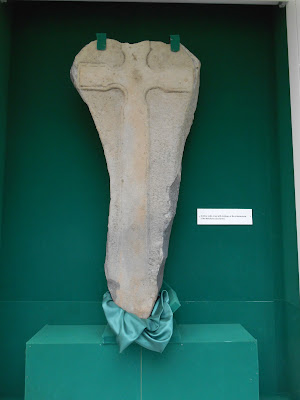
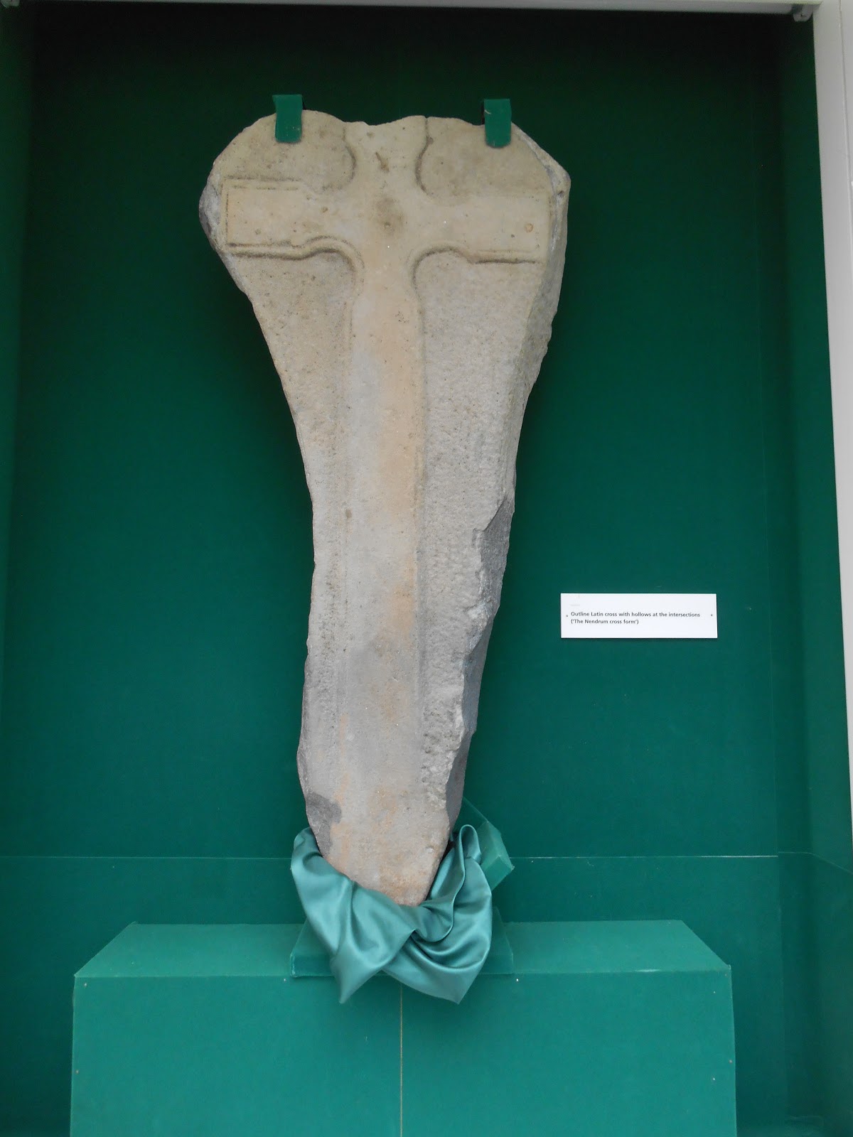
 An example of a Nendrum Cross in the Visitor Centre
This is a Latin Cross with hollows at the "armpits" where the arms meet the shaft.  This design is characteristic of Nendrum and a few other nearby sites in County Down.

 Nendrum Visitor Centre
 
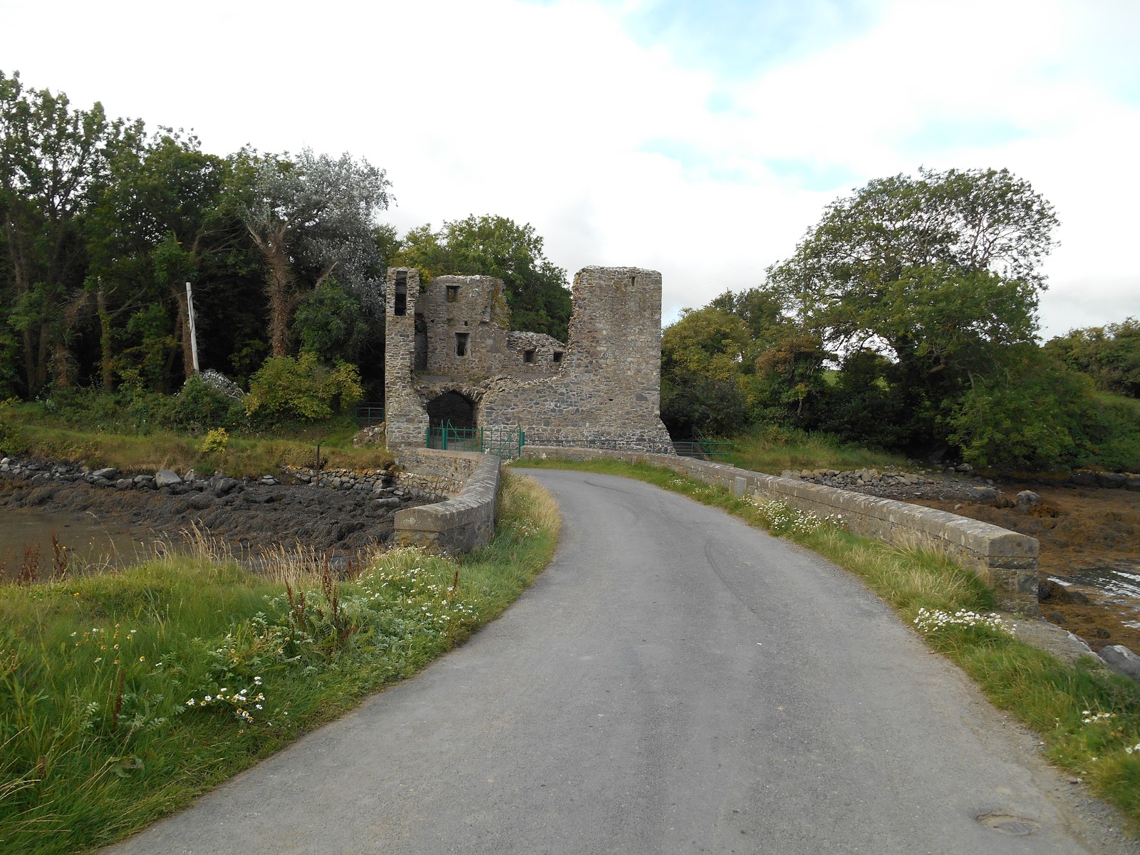
Mahee Castle is located at the western end of the island facing Reagh Island and adjacent to the modern causeway.  There is public access to the ground floor.  There is no car park but it is only about 300 metres from the car park at Nendrum.  I found lots of lovely blackberries to eat along the way.  The tower house is thought to have been built in 1570 by an English soldier called Captain Browne.  There was a secure boat bay on the ground floor.

 Mahee Castle

Mahee Castle from the Reagh Island Causeway

 Memorial plaque commemorating the building of the walls at the sides of the causeway between Reagh and Mahee Island
The walls were built in memory of a local man called Robert Ardill, who died on 30th October 1921.  According to the Comber Historical Society website he was a local man who either drowned or was killed by the shock of the cold water off Mahee Island when he fell in while transferring from one boat to another.  There is another much larger conical stone memorial to him at the eastern end of the island.  The only way to access this is by boat, as the land adjacent is private with no public access.

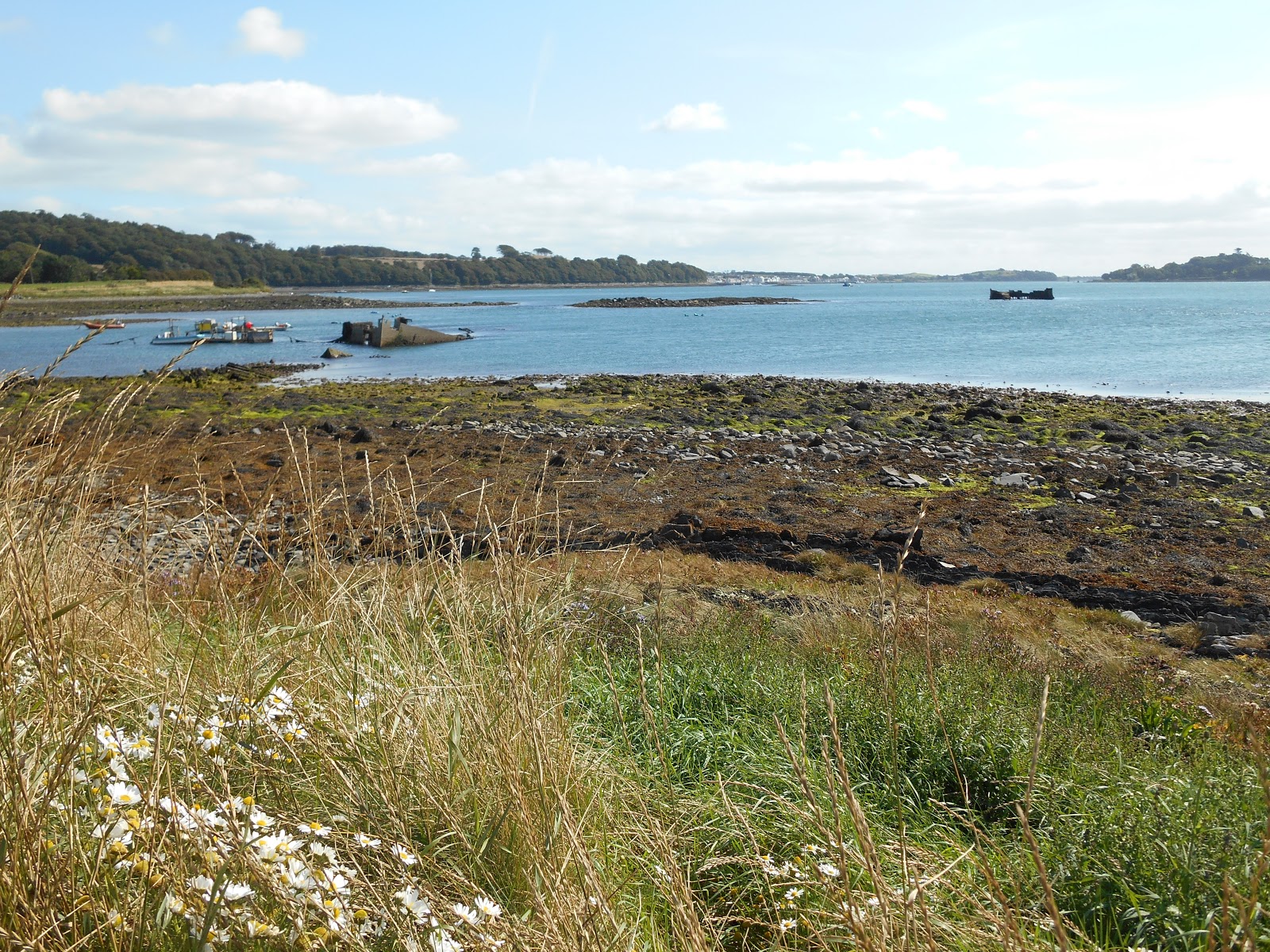
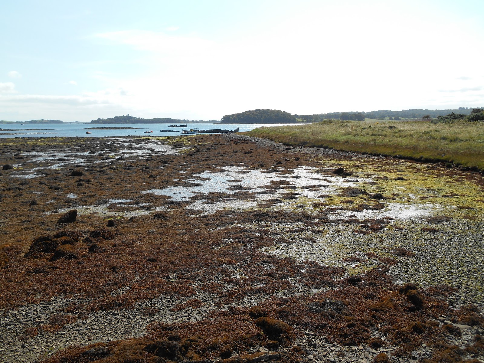
The remains of two very old tide mills can be seen from the monastic ruins.  These were excavated 1999-2001.  It had previously been thought that the remains were of fish traps.  There wasn't any fresh water on the island to provide power for a conventional water mill, so the monks constructed the first tide mill across the small bay below the monastic site in 619 (I have no idea how it has been dated so precisely).  This tide mill is currently the earliest known example of a tide mill in the world. At high tide the water was trapped behind a dam and then the water was released at low tide as a high pressure stream of water, which powered a horizontal water mill.  The second smaller tidal mill was constructed within the earlier on in 789.  Both can clearly be seen at low tide - see photos below.
 The oldest tide mill


The second tide mill

Friday 18 September 2015

Island 290 - Reagh Island, Strangford Lough, Northern Ireland

Reagh Island is a long thin island located about 3 miles to the east of the village of Lisbane on the western side of Strangford Lough.  It can be accessed by car via a causeway at all states of the tide.  The only public access to the island, apart from the public road, is a thin strip of land on the south east side of the island, which belongs to the National Trust - there is a small car park and a footpath running down the eastern side of the island for about 400 metres through the trees, although the southern part was very overgrown when I visited in early September 2015 in search of a geocache. 

Reagh Island is about a mile and a half long but only 600 metres wide at its widest point.  There are a few well scattered houses on the island, which is farmed. There is a causeway off the north eastern side of the island leading to the smaller Cross Island but there is a large notice saying that this island is private.

Causeway to Reagh Island from Mahee Island
The other side of the causeway that links Reagh Island to Mahee Island
 Looking south east towards Mahee Island

 Thankfully the National Trust own some land on Reagh Island, which means there is somewhere other than the road where you can walk freely.
 Beach adjacent to the National Trust car park

Cross Island doesn't welcome visitors
 Causeway to the mainland from Reagh Island

Lovely house - the first house on Reagh Island after you have crossed the causeway.

Thursday 17 September 2015

Island 289 - Rough Island, Strangford Lough, Northern Ireland

Rough Island is linked to the north western shore of Strangford Lough a couple of miles east of the town of Comber by a concrete causeway, which is covered for an hour or so at high tide.  It is owned and managed by Ards Borough Council and is accessible to the public.  There is a large car park and a public toilet at the end of the road at Island Hill.  There is a well surfaced path around the perimeter of the island.  There are a few other paths criss-crossing the island but when I visited in early September 2015 they were very overgrown.  The island is a favourite dog walking place, so you need to watch where you are treading.  

Rough Island is situated at the mouth of the Comber Estuary where the Comber River enters Strangford Lough. There are salt marshes in the estuary, which are important wildlife habitats.  In October 30,000 pale bellied brent geese arrive to feed on the seagrass or eelgrass, which grows abundantly in Strangford Lough.  They then spread out across other estuaries across the British Isles.  Many other kinds of wildfowl and waders feed on the inter-tidal mudflats.

In 1936 a group of American archaeologists from Harvard carried out excavations on Rough Island and found evidence of occupation during the Mesolithic and Neolithic periods e.g. a shell midden and worked flints.  Further surveys were carried out on the island or nearby Island Hill in by Queens University in Belfast in 1997 and 2003.

Rough Island was apparently inhabited up until the early 1900s and farmed up until the 1950s.  One source said that the remains of the farmhouse and its orchard could still be seen but I didn't find them.  Most of the island is covered with brambles, nettles, thistles and scrubby trees e.g. sycamore, pines, hawthorn, elder, ash, alder and willow.  I thought I spotted some Japanese knotweed as well.  Purple vetch, sea mayweed and rosebay willowherb were all in flower when I visited.


 Causeway to Rough Island

 Approaching Rough Island

 The coast of Rough Island

 A solitary tree on Rough Island

There are several seats around the perimeter path

Island 288 - Ballyhenry Island, Strangford Lough, Northern Ireland

Ballyhenry Island is located a couple of miles north west of the small town of Portaferry on the eastern shore of Strangford Lough.  It is a small tidal island owned by the National Trust.  It low lying and is only cut off from the mainland for a short time around high tide.  There is only about 20 metres separating the island from the mainland and the island is only about 200 metres long by 200 metres wide.   There is a small parking area by the side of the narrow but stunningly beautiful coast road and adjacent to the island.

The island is not grazed and is therefore covered in long rough grass.  When I visited in early September 2015 sea mayweed was flowering in many places on the island, along with rosebay willowherb, sea asters and dandelions.  There are a few scrubby trees e.g. hawthorn and some gorse bushes.  There are no formal paths but there are a few indistinct paths criss crossing the island.  On my walk around the island I disturbed a heron.  I'm not sure why but I really liked Ballyhenry Island.

There is a navigation light on the western shore of the island below the high tide level.

The wreck of the SS Empire Tana can be clearly seen off the south coast of the island at low water.  The ship, which is also known as Lee's Wreck, was built in Trieste in 1923 and originally called Carso.  She was captured by the allies from the Italians during the Second World War, renamed Empire Tana and was used during the D Day Landings as a blockship/part of the gooseberry harbour at Sword Beach.  She was on her way John Lee's breaker's yard in Ballyhenry Bay in 1946/7 but was blown on to a rock and broke in two.  The wreck is now a popular diving site and is noted for its conger eels.


Ballyhenry Island from the mainland

Navigation light on Ballyhenry Island
 Looking south down Strangford Lough towards Portaferry
The wreck is visible in the lough

 Ballyhenry Island

Looking north east towards the mainland