Saturday 29 September 2012

Island 177 - Gigha, Scotland

Gigha is served by an hourly car ferry from Tayinloan on the Kintyre peninsula and the journey only takes 20 minutes.  The island is 6.5 miles long by 1.5 miles wide and is situated 3 miles to the west of Tayinloan.  Bikes can be hired on the island, which is relatively flat.  The bike hire shed is next to the jetty where the ferry lands.   Being a lazy person I opted to take my car.  This also enabled me to visit 4 tidal islands on the same low tide.

When I told people I was going to Gigha almost everyone said they had never heard of it, so maybe the island needs to do more marketing if it wants to attract more visitors.  I spent a day and a night on this delightful island in early September 2012. 

Ownership of the island passed through a succession of people in the 20th century but in 2002 with the help of grants, loans and fundraising the islanders were able to buy the island, which is now run by the Isle of Gigha Heritage Trust.  Since then the population has increased from 110 in 2001 to around 150 in 2012.  The Heritage Trust has bought 3 wind turbines, which are known as Faith, Hope and Charity

The main visitor attraction on the island is the gardens at Achamore House.  They were planted by Colonel Sir James Horlick (of hot milk drink fame), who bought Gigha in 1944.  There are more than 50 acres of woodland gardens, including lots of rhododendrons.  The garden is open from dawn until dusk every day and you put your money in the honesty box at the entrance.  I had the gardens to myself when I visited, although there had been a coach party visiting earlier in the day.   I had a chat to their coach driver on my way to visit the ruined church in Kilchattan.  I was surprised that the enormous coach would have fitted on the ferry but it obviously did.  He said he had all his coach party's packed lunches with him and offered me some of their sandwiches.  I declined but did accept a chunky kit kat.  I hope one of his passengers didn't miss it!

There is a hotel at Ardminish and several self-catering properties and people offering bed and breakfast accommodation.  I stayed in the excellent Springbank Guest House.  My host was friendly and informative and it was very good value for money.  

Ardminish Harbour

Walled Garden at Achamore House

Viewpoint - Achamore House Gardens
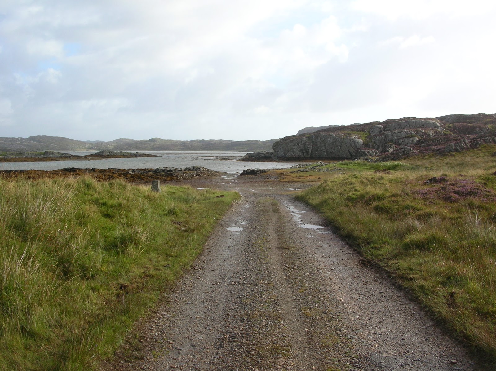
the island to the left is Eun Eilean, a tidal island, which I didn't manage to visit, as I was only on Gigha for one low tide.  However my motto is 'always leave something to come back for'.


Achamore House Walled Garden


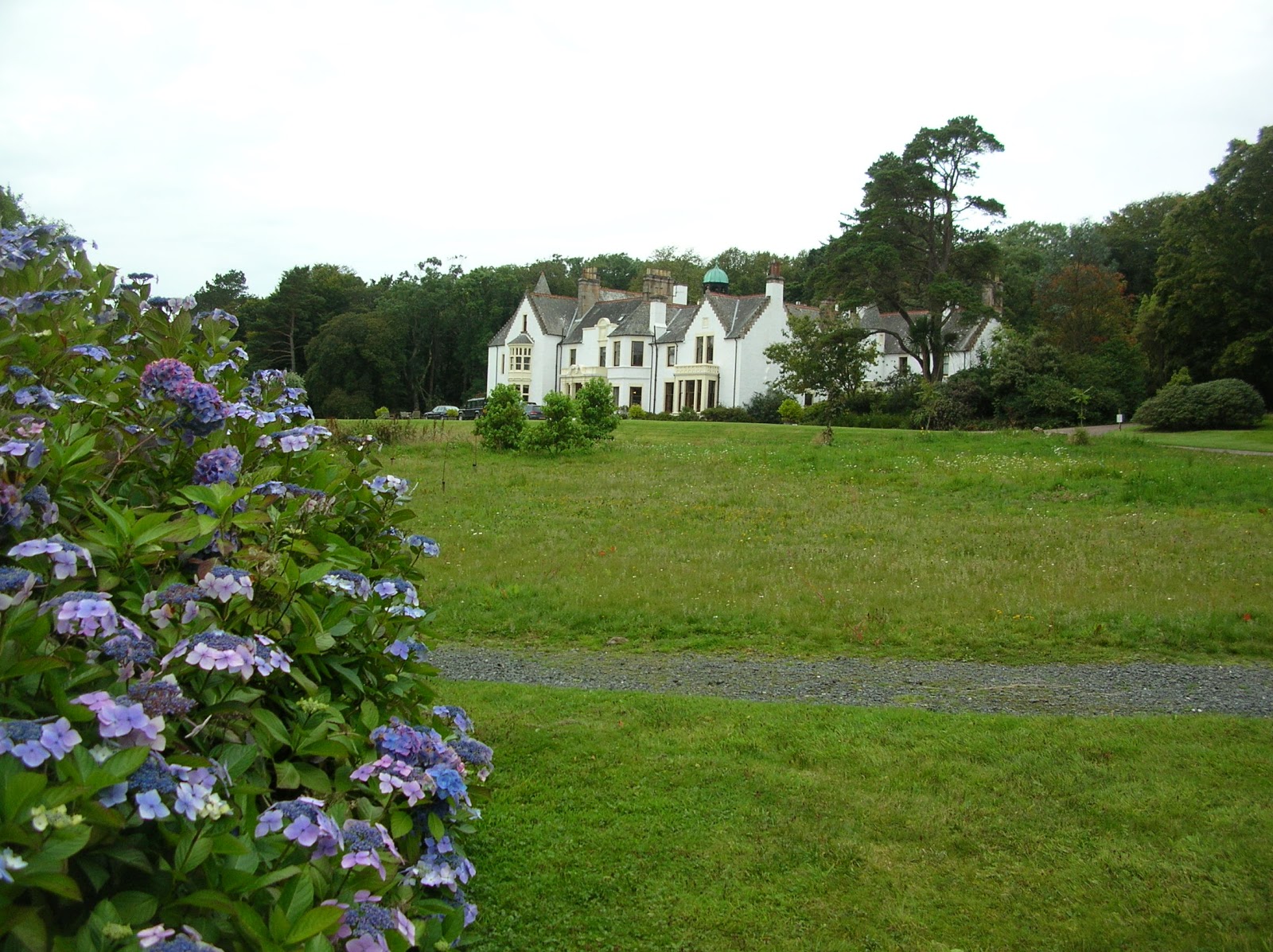
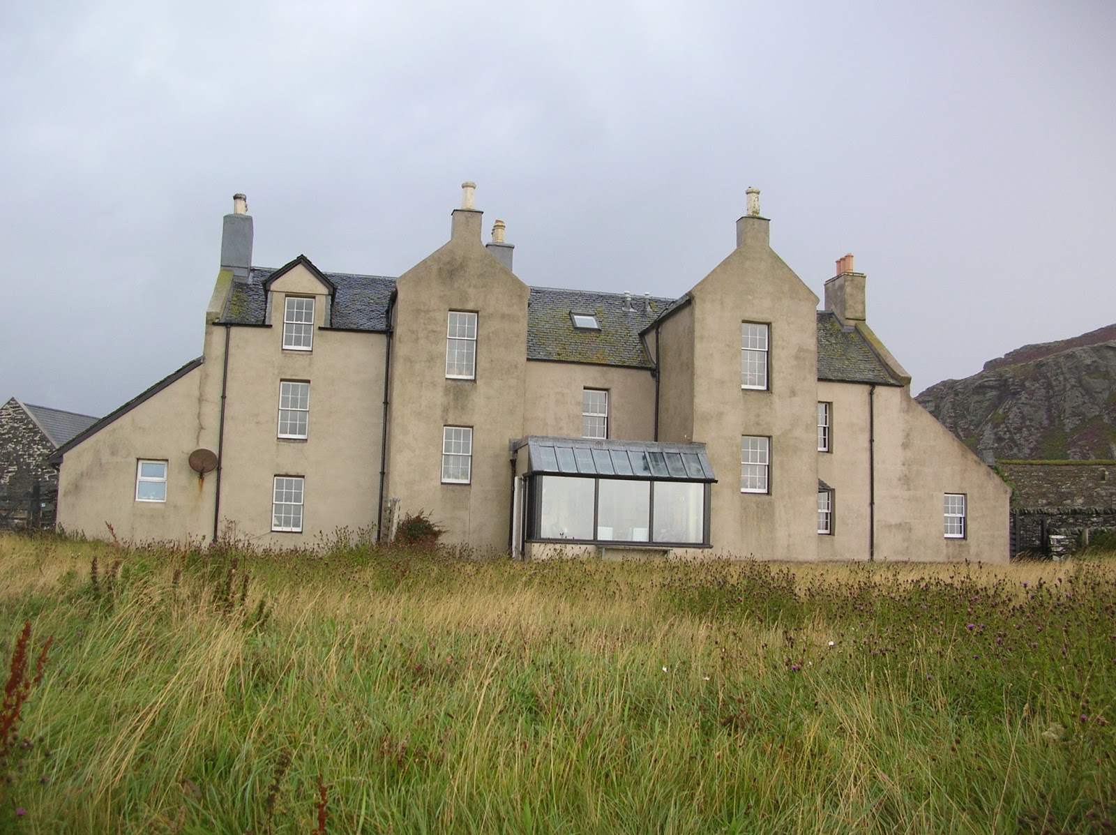
Achamore House
The house was built in 1884 but was badly damaged by fire at the end of the 19th century and was then rebuilt with 2 storeys instead of the original 3.
The Boathouse Cafe at Ardminish
  - sadly it was closed when I visited on a Monday in early September, as they only open at the weekends in winter!  I thought early September was still summer!

Ardminish is the main settlement on the island.  It is where the ferry comes in and the school, hotel, church and shop/post office are also located here.  The shop had all the essentials but I didn't think it was particularly well stocked compared to other island shops I have been in.  There is also a gallery selling art and crafts here.

Port a' Chinn Mhoir

Ardminish Church
Giant's Tooth Standing Stone beside the road at Tarbert
It is also known as the Hanging Stone, possibly because criminals were hanged from the top of it.  It may date back to the Bronze Age.


9 hole Golf Course

Ruined church at Kilchattan
There are several elaborately carved gravestones.  The church is dedicated to St Cathan, a 6th century Irish missionary, and dates from the 13th century.  It was replaced during the early 18th century by a new church opposite the hotel.  This was in turn replaced by the current building in the 1930s.
Ogham Stone at Kilchattan
This is one of only 2 known stones in Scotland with Ogham script carved into them.  Ogham is an ancient linear script, which originated in Ireland.

Fisherman's Cave
There is a path to this cave, which is signposted from the road just to the north of Eilean Garbh.  The path winds along for about half a mile and is a bit boggy in places.  The cave isn't that exciting when you get there but the walk to it is quite scenic.  It was used to store nets and creels.

 
Ardminish

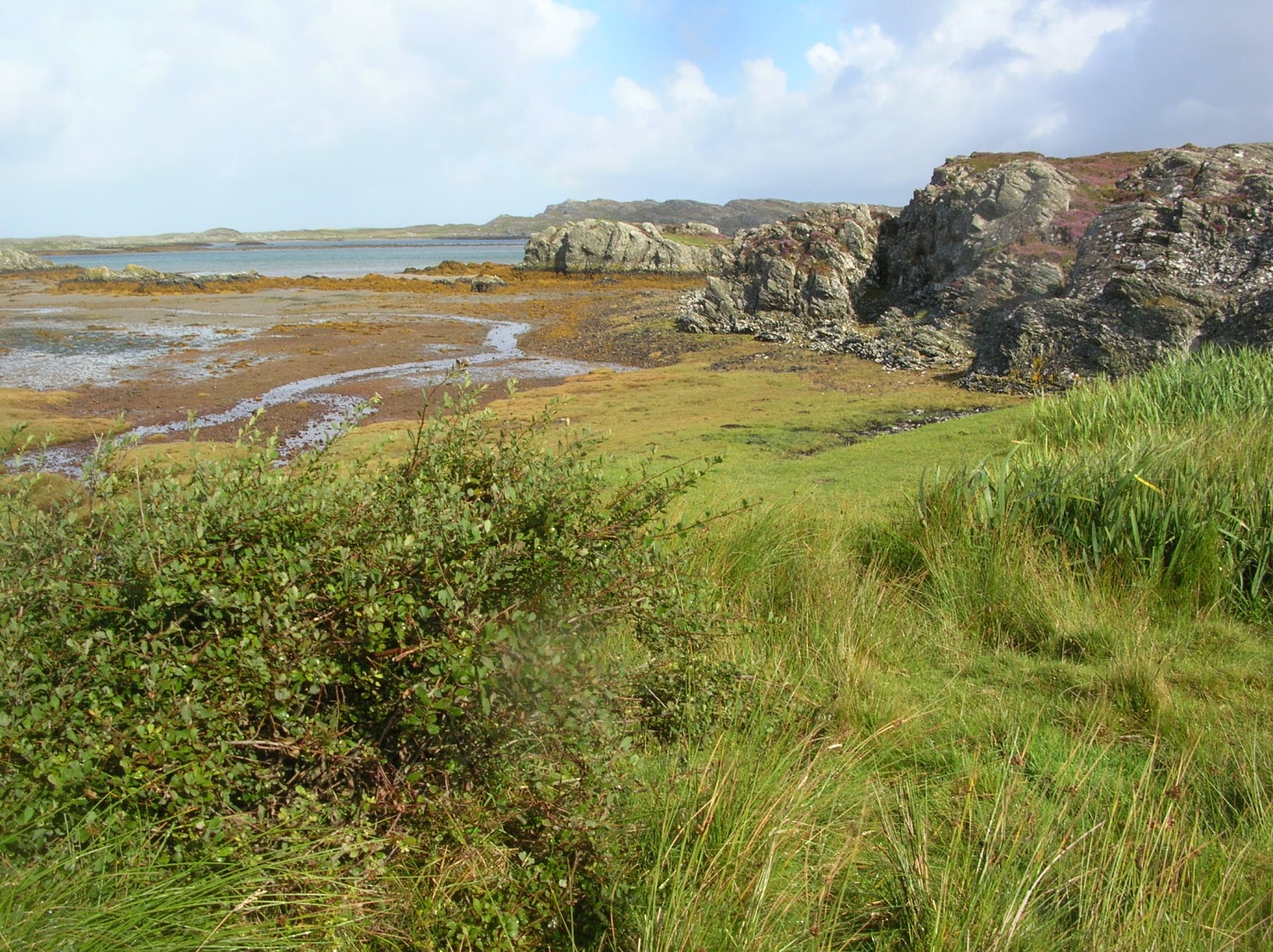
Port Righ at the northern end of the island

I'm not sure what this cairn at Ardminish is for but it was quite pretty

Stained glass window in the Parish Church of Gigha and Cara at Ardminish
One of the stained glass windows in the church is dedicated to Kenneth MacLeod, who wrote the song 'Road to the Isles'.  I'm not sure if it is this window or not, as there are several interesting stained glass windows.   Kenneth MacLeod was the first minister at the current church, which was built in 1923.

Monday 24 September 2012

Island 176 - Davaar, Kintyre, Scotland.

Davaar is a tidal island located at the mouth of Campbeltown Loch, a couple of miles east of the town of Campbeltown at the southern end of the Kintyre Peninsula in Scotland.   The shingle causeway, which is called the Doirlinn, is accessible for about 2.5 hours either side of low tide.  The island is owned by the Kildalloig Estate.

Davaar was known as the island of Sanct Barre, 1449 -1508. The modern name is possibly derived from double-pointed (Da-Bharr) Island or it may be named after St Barre.

Davaar Lighthouse  at the north end of the island was designed by David and Thomas Stevenson in 1854.  It was automated in 1983.

The Lookout, Island Cottage and Otter Cottage are all available to rent as self-catering holiday accommodation. 

The walk across the shingle Doirlinn is fairly easy going.  There is a clear grassy track on the island leading to the lighthouse and associated cottages.  There is a path up to the summit of the island but when I visited in early September it was very overgrown and towards the summit it becomes indistinct.  There are no trees on the island.  The higher slopes of the hill are covered in heather while lower down it is long grass, bracken and wildflowers like scabious, harebells and birdsfoot trefoil.


The wall painting of Jesus's Crucifixion in one of the island's caves was done in 1887 by local Art school teacher Archibald (or possibly Alexander) MacKinnon in secret after he had a dream telling him where to paint it.  MacKinnon left Campbeltown shortly after the painting was discovered due to the scandal he had caused but he did return in 1902 and 1934 to carry out some restoration work on the painting.  Since then the painting has been restored again in the 50s and in the 70s by art teachers from Campbeltown Grammar School.  It was damaged in 2006 when someone painted an image of Che Guevara over it but has since been restored.

To get to the cave painting you need to turn south east as soon as you arrive on the island.  The path is grassy at first but then you have to walk across the beach, which consists of boulders of varying sizes.  The cave painting is in the 5th cave along (or the 7th depending on which source you believe - I have to say that I lost count of the number of caves I looked in before I got to the right one).  I walk quite fast but it still took me nearly 20 minutes to get to the cave.  When you get to the right cave there is a painted sign.  It is very dark inside, so a torch would have been useful.  However it was light enough to see the painting.

 
It was a 5 mile round trip by the time I had walked to and from the island, walked to the cave and lighthouse and back and climbed to the highest point on the island, which is 110 metres above sea level. 

On the evening I visited 7 other people crossed over to the island.  2 of them only stayed a few minutes, 2 ladies followed me to the cave but gave up before we reached it and I had a long chat to an older American couple, who holiday in Kintyre every year because they love it so much.  I met 3 people by the houses near the lighthouse and a couple of people were fishing off the beach near the lighthouse.   I liked Davaar very much.  It has a variety of terrains and is easily accessible but not overcrowded.
 

Davaar at high tide

Davaar from The Doirlinn

Sheltered bench near the lighthouse


 Cave painting of Jesus on the Cross -
The smaller painting to the right says underneath it "I did all this for thee, what wilt thou do for me"

This is the cave with the painting of Jesus

Fishing at low tide from beneath the Lighthouse

Feral Goats  
- you'll smell them before you see them!


Island Cottage - available to rent as holiday accommodation

Jetty on the north coast

Navigation light halfway across The Doirlinn

Lighthouse, Otter Cottage and Island Cottage


Trig Point

The Lookout - a former World War 2 lookout post.


The Doirlinn from the trig point

The Doirlinn approaching low tide - from the trig point on Davaar

Thursday 20 September 2012

Island 175 - Eilean Ceann na Creige/Kennacraig, Kintyre, Scotland

Eilean Ceann na Creige or Kennacraig is a tidal island which is connected to the mainland by a road, as the island is used as Calmac's Islay and Colonsay ferry terminal.  Therefore it isn't the most scenic of islands.  Much of it is now a car park but some of the northern side is still covered with grass, reeds and scrubby trees.

 Presumably this is what the whole island looked like before the ferry terminal was built

 Causeway to the mainland

 Islay ferry Finlaggan
 
 Finlaggan - new boat

 Welcome to Kennacraig

Wednesday 19 September 2012

Island 174 - Eilean an Rubha, Jura, Inner Hebrides

Eilean an Rubha is a small tidal island located to the south of Inverlussa, which is on the east coast of Jura.  It can be accessed across the beach from Inverlussa at low tide and is obviously visited by the cows, who were sitting on the beach, due to the presence of cow pats on the island.  The gap between Jura and Eilean an Rubha is only about 30 metres wide.  There were also a couple of discernible paths, so presumably it is also visited by people.  It was a pleasant spot to spend a while exploring on a sunny morning.

The island is covered in rough grass, heathers, gorse, sedges, moss and bracken and wild flowers like thrift, tormentil and scabious.  


 Looking south down the coast of Jura -
bright orange lichens are growing on many of the rocks

 Rocks smoothed and scratched by glaciers?
Looking north towards Inverlussa

Island 173 - Dubh Eilean, Oronsay, Inner Hebrides

Dubh Eilean is a small uninhabited tidal island located off the west coast of Oronsay.  It is only separated from Oronsay by a small channel, which clears at low tide to leave a sandy beach.  It is unremarkable and consists of grass covered rocky outcrops.

 Oronsay from Dubh Eilean

 Typical landscape on Dubh Eilean

 The narrow channel separating Dubh Eilean from Oronsay

The sun has come out for a minute!

Island 172 - Oronsay, Colonsay, Inner Hebrides, Scotland

There are several islands with the name Oronsay, which means tidal island in Old Norse, although in this case the name may be derived from St Oran, who came to the island from Ireland in 563 AD.  St Columba is also said to have come to the island and founded a monastery here.  However he moved on to Iona when he realised that he could still see his home country of Ireland from Oronsay.   The Christian missionaries were not the first to visit Oronsay, as there are several Mesolithic shell mounds on the island.  Excavations of these have revealed bone and stone tools and midden materials.

This Oronsay, which is also sometimes spelt Oransay, is located immediately to the south of the island of Colonsay in the Inner Hebrides.  At low tide it is linked to Colonsay by The Strand.  According to the Colonsay website it is accessible for about 2.5 hours either side of low tide but it also says that sometimes it doesn't clear at all if it is a neap tide and a strong wind is blowing.  Although Colonsay and Oronsay are only 250 metres or so apart at their closest crossing point, the recommended route is a mile across the sand.

Low tide on the day I wanted to visit was at 10.15, so I got out of bed early and was ready to cross by 8am.  However having parked my car at the end of the road I realised that there was still water between me and Oronsay.  I set off wearing my walking boots in the hope that the water was just a mirage but half way across The Strand I realised that there was about 300 metres of water to cross.  At this point an intrepid family from Letchworth joined me and we debated the best place to cross.  It was good to have some company.  A couple of people had waded across successfully ahead of us, so after a while we decided to follow them.  To avoid ruining my walking boots I put on a pair of crocs and we waded through the cold water, which in places was knee deep.  

Not wanting to get stranded we quickly walked the mile or so to the Priory and then down onto the delightful and empty silver sand beach at Port na Luing.  I left the family there and went off to 'collect' another island - Dubh Eilean.  The heavens decided to open at this point for about 10 minutes, then the sun came out and we were treated to a lovely rainbow.

On our return journey we paused to have a look round the Priory ruins, which are extensive.  There was a notice next to the entrance, which said car park. I can't imagine wanting to drive across The Strand but I suppose with a 4x4 it would be possible.

We could probably have spent longer on Oronsay but decided that we would walk straight back across The Strand, which was clearer than when we had crossed earlier but still not dry.  I have subsequently read and heard of several people who stayed too long on Oronsay and nearly got cut off by the incoming tide, so was glad had erred on the side of caution.

The current Priory buildings are the remains of the Augustinian Priory founded in 1380, although they are thought to be on the site of the earlier one founded by St Columba.  The farm next to the Priory was built by the McNeils with stones taken from the Priory.

There is apparently a sanctuary cross half way across the Strand, although I didn't see it.  In the past fugitives from Colonsay who reached the cross could claim immunity from punishment if they stayed on Oronsay for a year and a day.  There is also a rock that looks like an elephant's head, at the Oronsay end of the Strand crossing.  However I didn't notice this either.  I must pay more attention on my next visit.

Oronsay was sold by Lord Strathcona in the 1970s to an American.  It was bought by another in the 1980s and is now leased to the RSPB.

The whole of the island of Oronsay is designated a Site of Special Scientific Interest (SSSI) and Special Protection Area (SPA) for its chough and corncrake populations.   I didn't see any choughs on Oronsay but I encountered a couple at Kiloran on Colonsay.

The island is farmed by the RSPB with a mixed farming regime with cattle and sheep, late cut grass and arable crops grown for corncrake conservation. All other areas are managed for choughs by grazing regimes.

Other important species include breeding waders (lapwings and redshanks), farmland birds (twites, skylarks, linnets) and wintering geese: barnacle geese and Greenland white-fronted geese. Habitats include dune grassland, machair, in-bye grassland and heath/acid grassland.

The recommended crossing point - approaching Oronsay

A 4x4 crossing The Strand - approaching Colonsay

Cloisters at Oronsay Priory

Oronsay Priory
 
Oronsay Priory
 
Port na Luinge Beach
 
North coast of Oronsay approaching the crossing point

Oronsay Farm next to the Priory

Priory Cottages
 Oronsay Priory

 Oronsay Priory - Celtic Cross

 Oronsay Farm 

 Collection of carved tombstones

 End of the road - approaching The Strand

 Rainbow over Port na Luinge

  Beinn Oronsay - the highest point on the island