Monday 15 October 2012

Island 183 - Rough Island, Dumfries & Galloway, Scotland

This is an island of which very few people seem to have heard.  It is a small uninhabited tidal island located half a mile to the SW of the village of Rockcliffe in Dumfries and Galloway.  It is accessed by a natural causeway of small stones, cockle and mussel shells and barnacles to the north of the island, which starts half a mile south of the village of Kippford.

The island is owned by the National Trust for Scotland and managed as a bird sanctuary.  Access is not permitted in May and June during the breeding season.  It covers an area of 8 hectares and is about 500 metres from north to south and 250 metres from east to west.

I parked in the main car park at Kippford but there was parking for about 12 cars half a mile nearer to the Rough Island causeway.   The causeway itself is just over half a mile long.  I arrived on the beach of whole cockle shells to the south of Kippford and could see the causeway but there was about 200 metres of mud to cross to reach the start of it.  Thankfully the mud was hard enough to walk across.  Low tide on the day I visited in early September 2012 was at 9.45 am, so I arrived on the island at 8.45 and had it to myself. 

I have not been able to find out much about the island.  Even the National Trust for Scotland seem to keep quiet about it, as it gets only a passing mention on their webpage about the land they own at Rockcliffe.

The island is covered in scrubby trees (mainly hawthorns), bracken, brambles, grass, gorse and wild flowers.  The wildflowers in bloom in early September included scabious, thistles, bird's foot trefoil, ragwort, heather, broom and rosebay willowherb.  There were plenty of ripe blackberries, so I ate a few.   Down on the rocky beach that fringes the island there were Michaelmas daisies, thrift, sea campion and sea lavender.  There is a clear path running up the spine of the island from the northern tip to the summit, which is 24 metres above sea level.  The bracken on either side of the summit path looked like it has been managed, presumably to allow more interesting vegetation to flourish.

I thought Rough Island was going to be a bit dull and an anti-climax after all the interesting islands I had visited in the previous fortnight.  However I was wrong.  On a sunny morning it was a delightful place to 'stand and stare' for a while and being the only person on it added to the experience.   I look forward to visiting some more of Dumfries and Galloway's tidal islands in the years to come.

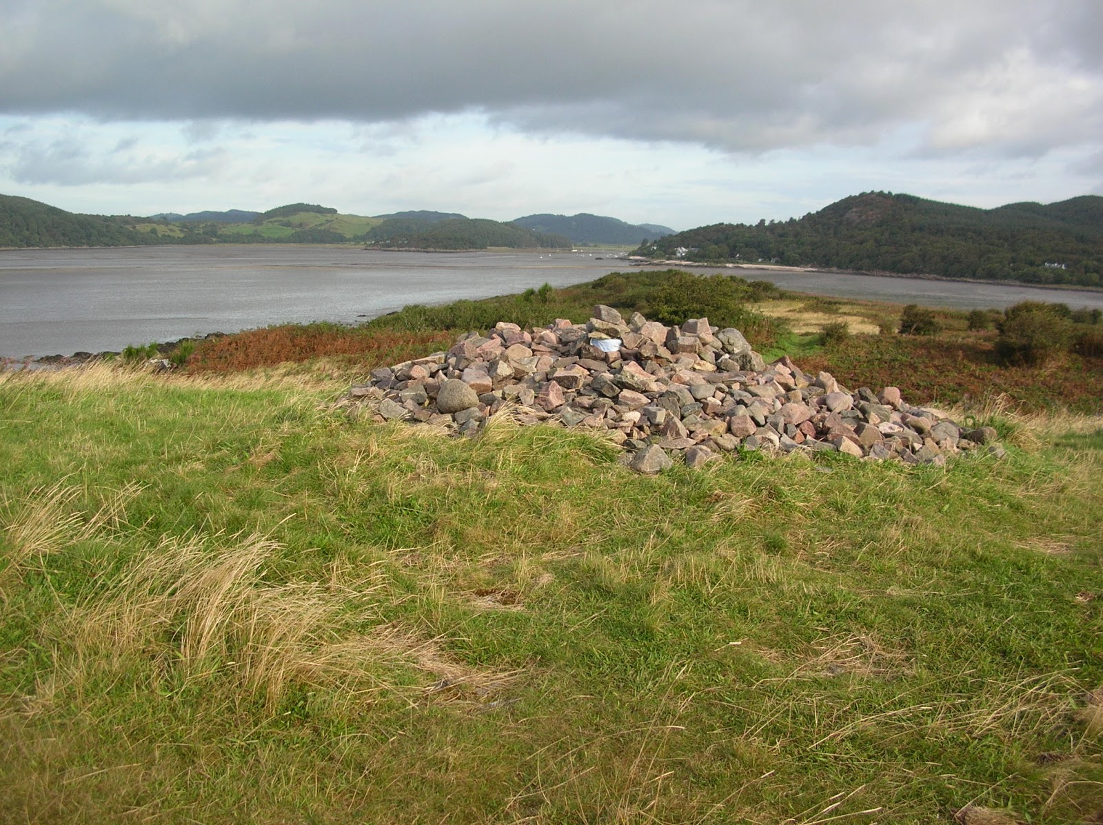
 Rockcliffe from the summit cairn
On top of the cairn under a couple of rocks there is a battered tin, which contains a logbook for visitors to write their thoughts in - much like a geocache really. Judging by the comments in the book, some people visit the island regularly. 

 Summit cairn looking north towards Kippford
 
 Looking north towards Kippford along the causeway

Causeway to Rough Island
 
Looking north towards Kippford
 
I think the nets off the east coast of Rough Island are for some kind of traditional fishing

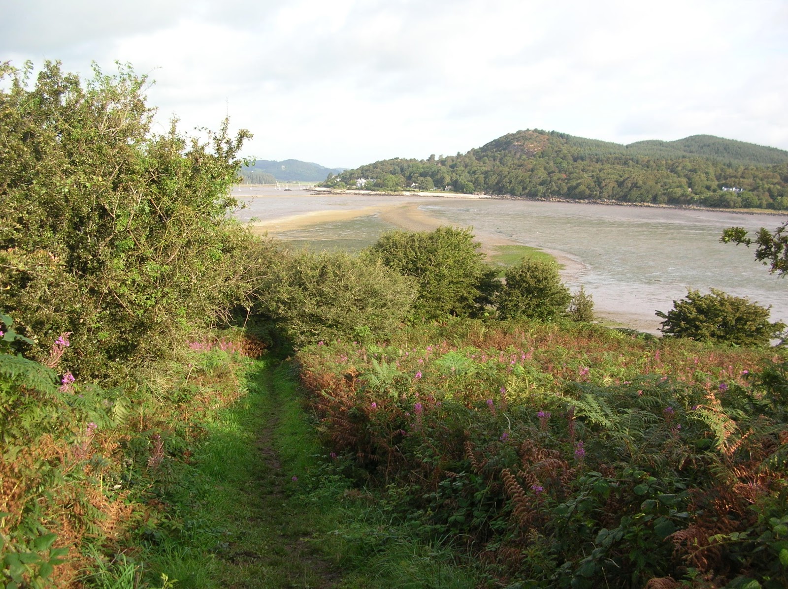
Clear path up the spine of the island to the summit.  Looking north towards Kippford.

 Hestan Island from the summit of Rough Island
Hestan is in the top right of the photo.  It is also a tidal island but the causeway to it, known as the Hestan Rack, only clears when there is a spring tide and then not for very long.  It is also a 3 mile way each way from the nearest parking point. 

Top of the island looking towards the summit
 
Rough Island from Kippford beach


Kippford - macabre memorial 

On the footpath from Kippford to the Rough Island causeway there is a garden, which is full of strange sculptures made from stones, driftwood and other materials.  There is even a fairy grotto.  The more you look at it, the more you see.  I thought it was great.  

A couple of the driftwood sculptures

Wednesday 10 October 2012

Island 182 - Holy Island, Arran, Scotland

This delightful and peaceful island lies to the east of Arran, approximately 1.5 miles to the east of Lamlash.  It is 2 miles long by half a mile or so wide, depending on where you measure it.

I visited for a couple of hours in early September 2012. I had hoped to visit the previous day and spend longer there but the boats were cancelled due to high winds.  On the day I visited the time of low tide meant that the first boat did not run until 11.30 am. I had booked the Ardrossan ferry for 5pm, which I didn't want to miss, so played it safe and left on the 2.15 pm boat from Holy Island.  I walked very fast and made it as far as the Pillar Rock Lighthouse and still had a bit of time to spend wandering around the community garden and the north end of the island.

In 1992 Holy Island was bought by the Rokpa Trust whose main base in the UK is the Samye Ling Monastery and Tibetan Buddhist Centre in Dumfries and Galloway.  On their leaflet they describe themselves as custodians of the island rather than owners, which is true as none of us will be on this earth for ever.  At the north end of the island is the Centre for World Peace and Health, which offers various courses and guesthouse accommodation for people seeking a quiet retreat.

Holy Island can be accessed in the summer months by passenger ferry from Lamlash.  The journey across takes about 15 minutes.

Visitors are asked to observe the following rules:
Protect all life and refrain from killing
Do not smoke, drink alcohol, camp or light fires on the island
Do not bring dogs or bicycles onto the island.

Soay sheep, wild Saanen goats and Eriskay ponies roam free around the island.  When I visited the Soay sheep were around the guesthouse, the goats were on the west coast and the ponies were at the south end of the island. I can't remember if there are any gates separating them.

Since 1992 the Buddhists have planted 35,000 native trees in 3 plantations - 2 in the south of the island and a bigger one in the north.  They have also chopped down lots of invasive rhododendrons.

There is a clear flat path down the west coast of the island.  It curves round at the southern end and ends at the Pillar Rock Lighthouse on the south east coast.  There is no path up the east coast.  The highest point on the island is Mullach Mor at 314 metres.  There is a path over the top but I was limited for time, so didn't use it. 

 Holy Island ferry at Lamlash

 Holy Island from Lamlash

Boathouse Information Centre
Day visitors are offered a complimentary tea or coffee (but no cake or biscuits) but when I visited the hostess wasn't at home, so I missed out. 
There are seats inside and a few Buddhist items for sale. 

St Molaise's Cave half way down the west coast
St Molaise is supposed to have lived in this cave as a hermit in the 6th century.


Stupas
Not sure what these flags and pillars are all about but they make the place look cheerful. 

 Retreat House from the kitchen garden

 Community Garden
There are inspirational quotes and verses and Buddhist paintings scattered around the garden, which is a sheltered and peaceful spot.

Centre for World Peace and Health -
60 bed guesthouse and conference hall for courses and retreats

 A hobbit house? - south end of the island

Buddhist rock painting - west coast

 Buddhist rock painting
 
 Buddhist rock painting

Buddhist rock painting

Buddhist rock painting

 More painting on rocks - west coast

Pillar Rock Lighthouse - 
south east corner of island

 Pillar Rock Lighthouse

Lighthouse at the south west corner of the island
This is out of bounds to visitors, as it is currently in use as a long term (4 year!) retreat. That's a lot of time to think!


Feral Saanan goats - you smell them before you see them!
 
Soay sheep near the landing jetty - no smell!
Interesting sculpture on the north coast - I have no idea what it is meant to represent!
East coast - no path, out of bounds

Holy Spring
The notice says the water quality is not up to EU standards.  I didn't try it.

Path down the west coast

These 'houses' at the south end of the island are used for people on retreat

West coast

Wednesday 3 October 2012

Island 181 - Eilean Garbh, Gigha, Scotland

Eilean Garbh is a tidal island linked by a tombolo to the Isle of Gigha.  It is about 800 metres long by 400 metres wide.  The island is covered in almost impenetrable undergrowth.  The lady whose guesthouse I stayed in on Gigha, used to farm at this end of the island and she said that before cattle could use Eilean Garbh for grazing they had to burn off all the undergrowth.  However it isn't currently used for grazing and the undergrowth has grown back.  She also said that the tombolo that links Eilean Garbh and Gigha and which currently is covered in grass, hasn't been this permanent looking for all that many years and that previously there was only sand connecting the 2 islands, which would be covered at high tides.  It would seem that the tombolo goes through various lifecycles and that the vegetation on it can easily be destroyed by high storm tides.

The beach at Bagh na Doirlinne squeaks if you scuff your shoes along it in the same way as the more famous Singing Sands of Eigg.  However I cannot find any reference to it being a 'singing sand'.  However it is a great place for a picnic and there was a family doing just that when I was there. 

 Eilean Garbh from Bagh na Doirlinne
 
 Bagh na Doirlinne from Eilean Garbh

Eilean Garbh from Bagh Rubha Ruaidh

Island 180 - Creag Iain Fiodh, Gigha, Scotland

Creag Iain Fiodh is a small tidal island in a bay called Bagh Rubha Ruaidh.  It is located between Eilean Garbh and Gigha.  It is an attractive tree, grass and heather covered island and is only separated from Eilean Garbh by about 20 metres of silver sand.

When I visited in early September 2012 the beach was covered with jellyfish that had been washed up by the last tide.  I don't know if they were dead (how does one tell if a jellyfish is dead?) or just waiting to float away on the next high tide but one certainly was dead after I accidentally trod on it! Thankfully I was wearing walking boots, as jellyfish can give you a nasty sting.  I think I have identified the jellyfish as lion's manes.  If this is correct, then this species does sting.

 One of dozens of jellyfish on the beach

 Eilean Garbh is on the left, Gigha is on the right

 Looking towards the tombolo that links Eilean Garbh to Gigha

Tuesday 2 October 2012

Island 179 - Eilean Bracach, Gigha, Scotland

Eilean Bracach is a small tidal island linked at low tide to Gallochoille on the Isle of Gigha.  There is only about 30 metres of hard mud and sand separating them.  Compared to Ardminish Point, this island was very easy to access.  I parked at Achamore House Gardens Car Park and walked half a mile down a track passed a couple of houses, on to a small beach where a couple were preparing to go kayaking and picked my way carefully across the mud, which thankfully was quite hard.

Eilean Bracach is an unremarkable flat island covered mainly in rough grass, scrub, reeds and heather with lots of rocky outcrops.  There were a few wild flowers in bloom when I visited in early September 2012, including what looked like some Michaelmas daisies.

Gallochoille from Eilean Bracach

Eilean Bracach

Ardminish from Eilean Bracach

Monday 1 October 2012

Island 178 - Ardminish Point, Gigha, Scotland

Ardminish Point is a tidal island linked to Gigha at low tide.  The gap between the islands is only about 30 metres and at some point in the past a low dry stone causeway has been built between the two islands.  However it is broken down in parts and some of it is covered at high tide.

The island is only about half a mile from where the Calmac Tayinloan to Ardminish ferry docks.  However there is no clear path to it.  I picked my way across a bay and over a low headland and following paths made by cows I managed to get within about 50 metres of the crossing point before the paths vanished and there was impenetrable scrub in front of me.   I backtracked and picked up another cattle path, squelched through several boggy bits and eventually found a way round.  Later in the day I was talking to the lady who runs the B&B I stayed in and she said that parts of the island are not grazed by cattle as much as they were in the past, which is why this and some other parts of the island are very overgrown.

Ardminish Point is an unremarkable island covered in bog, heather, grass and low scrub.  It is probably of little interest to anyone except island collectors.  The lack of paths to it suggests that it isn't often visited by the inhabitants of Gigha.

On the way to Ardminish Point I passed a couple of small tidal islands, which both had just about enough grass to graze a sheep.  However as neither of them appear to be named on any map I have found, I cannot add them to my collection.

 Gigha from Ardminish Point

 Remains of the rocky causeway separating Ardminish Point from Gigha

Unnamed island in Druimyeon Bay


Ardminish from unnamed island


Unnamed island, Ardminish