Wednesday 28 December 2011

Island 160 - St Mary's Island, Chatham, Kent

St Mary's Island is not mentioned in any of the many island books I own.  I stumbled upon it while looking for information on St Mary's in the Isle of Scilly.  It was once just a salt marsh but when the Chatham Dockyard was being created, the mud that was dug out of St Mary's Creek was deposited on the island.  The island is now a new housing estate and very lovely the houses look too.  However it isn't far above sea level and if I lived there I would be a bit worried about this fact.  The highest point on the island is only about 4 metres above sea level.   Canvey Island across the Thames Estuary and the Isle of Sheppey were both flooded extensively in the storm surge of 1953.  

The Romans constructed a road to the island and operated a ferry from Finsborough Ness to the Hoo Peninsula.  The ferry survived until the late 19th century.

In 1667 during the 2nd Anglo Dutch War, in order to protect against an attack by the Dutch Navy, old ships were sunk across St Mary's Creek and between the island and Upnor on the other side of the River Medway.  However the Dutch Navy under Admiral de Ruyter avoided the sunken ships, broke through a chain, which had been stretched across the Medway, destroyed 13 vessels and towed 2 away.

From the Napoleonic Wars to the end of Queen Victoria's reign the River Medway alongside the island was used to accommodate hulks - decommissioned naval ships, which housed criminals and prisoners of war.  Convict labour was used to dig out St Mary's Creek to create 3 basins.  These were completed in the 1870s and were used by the Royal Navy until 1984.

In the mid 1990s there was a competition to create a masterplan for the regeneration of St Mary's Island.  English Partnerships chose the submission made by Countryside Properties.  150 acres of the island has been developed as housing by Countryside Maritime - a partnership between the South East England Development Agency and Countryside Properties.  The island had to be decontaminated before the houses were built.  I think that might worry me a bit too if I lived there.
 
It took 3 years to remove 1.2 million cubic metres of soil from the site and replace it with uncontaminated soil.  I wonder what they did with all the contaminated soil?


St Mary's Primary School and Church
There is also a Community Centre and a doctor's surgery on the island and several purpose built play areas.


Typical St Mary's housing


Looking towards Kingsnorth Power Station


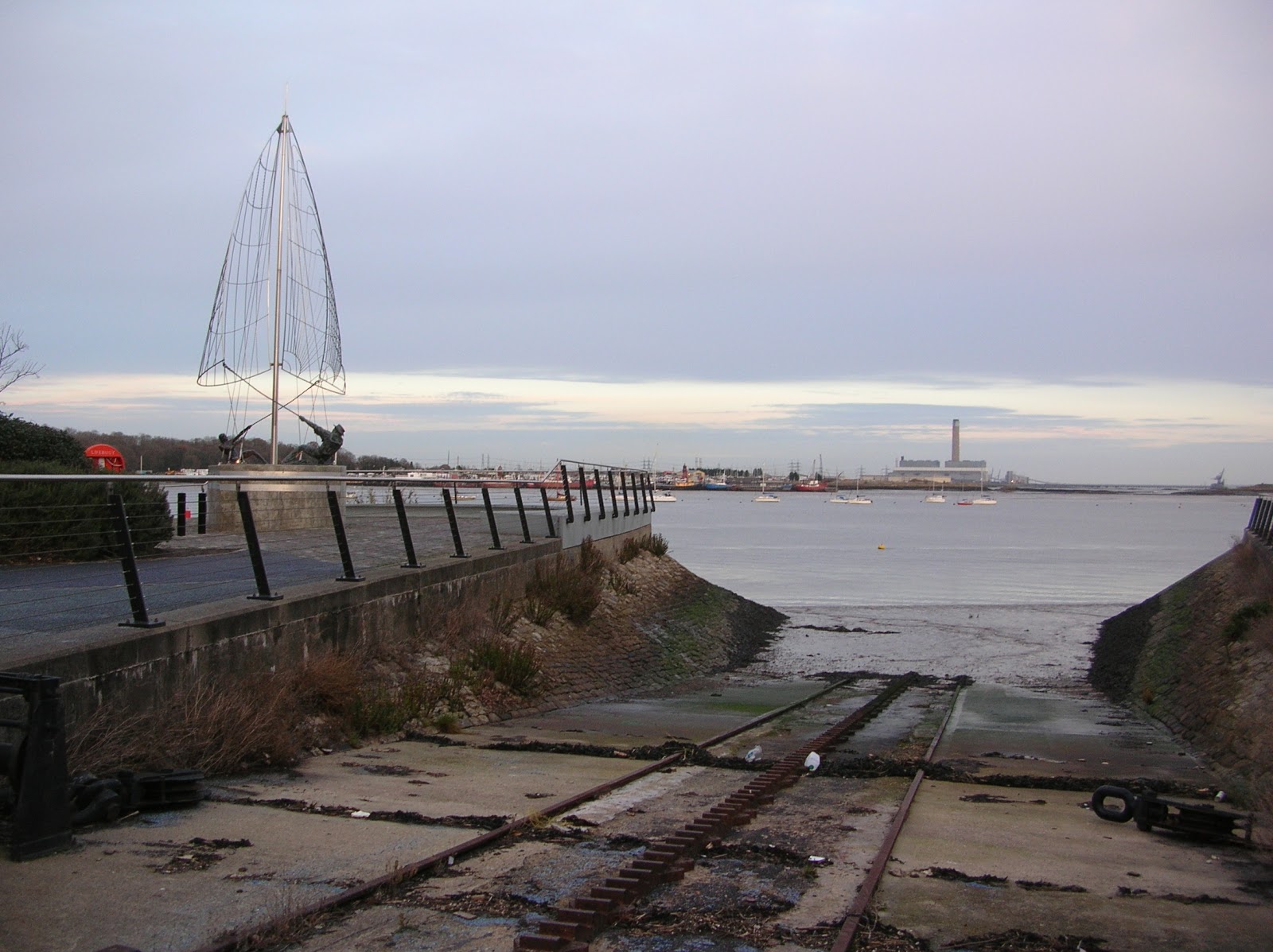
Slipway and sculpture at Finsborough Ness
 
The Mariners Sculpture, Finsborough Ness


Lots of lovely oozy mud at low tide!


Flats on St Mary's Island
Looking towards St Mary's Island from Chatham

Island 159 - Isle of Harty, Sheppey, Kent

The Isle of Harty is located in the south east corner of the Isle of Sheppey and is bounded on the east by the North Sea, on the south by The Swale and to the north by the Capel Fleet.  The highest point on the island is 27 metres above sea level.  There are a couple of farms on the island, the church of St Thomas the Apostle, a couple of houses and the Ferry Inn.  There used to be a ferry across The Swale from Harty to Oare.

Harty is access down a 3 mile long supposedly metalled road, which comes off the B2231 between Eastchurch and Leysdown-on-Sea.  The road is very potholed, so would not be good if you are in a hurry or it is dark.  I followed 5 4x4s down the road.  I thought they were birdwatchers but when they parked up they all got out with shotguns in their hands, so presumably they enjoy killing birds, rather than watching them!

13 services a year are held in St Thomas's Church.  The church has no electricity and so is lit by candles and paraffin lamps.  I don't know if it is normally open but I visited on Christmas Eve and someone was preparing the church for a service that evening.  Part of the building dates back to the Norman period.

 St Thomas's Church looking north

 St Thomas's Church looking south towards The Swale


 Stained Glass windows in St Thomas's Church - To Everything there is a Season
There is a window representing each season.

Capel Fleet where the road crosses it - looking west

One of the best places in the UK to watch birds of prey?
 
The Ferry Inn
Looking south from near the Ferry Inn - salt marshes and The Swale


Peacock
I know the Isle of Harty is a good place to watch birds but I wasn't expecting to see a peacock! This chap was happy to pose for photos

Island 158 - Elmley, Isle of Sheppey, Kent

Elmley Island is one of the 3 islands that make up Sheppey.  The other 2 are the main Isle of Sheppey and the Isle of Harty in the south east corner of Sheppey.  Elmley is located in the south west corner of Sheppey and is bounded on the south by The Swale and to the north by the once partially tidal Dray, which meets The Swale near Ridham Dock in the west and becomes Windmill Creek, which meets The Swale near Spitend Point in the south east.  The Dray and Windmill Creeks are no longer tidal since the building of seawalls at each end.  Elmley Island is low lying.  The highest point is 12 metres above sea level.

In 1688 King James II was captured in the Elmley Marshes by local fishermen while trying to flee to France and was held overnight at Kingshill Farmhouse.

In 1854 century the Elmley Cement Works (also known as the Turkey Cement Works) was built on the west coast of Elmley. The workers lived in a small village on the island with c35 houses.  There was also a school, a pub and a church.  The village was located half a mile due west of Kingshill Farm.  After the cement works closed in 1901 the village died.  The church was demolished in the 1960s, although one or two gravestones remain but the ruins of the school can still be seen.

The island is a National Nature Reserve.  When I visited on Christmas Eve 2011 it was managed by the RSPB, but it is now managed by the private landowner.  I'm not a great bird watcher but I saw a curlew and lots of lapwings.  There is a public toilet at the car park, which is 2 miles down a rough track.  The track comes off the B2231 near the Kingsferry Bridge.  It is not accessible from the new Sheppey Crossing.  Dogs (except assistance dogs) are not allowed. There is currently (11/2023) an admission charge of £8 per adult. You are asked stay in your car on the entrance track to avoid disturbing the wildlife.

Avocets, curlews, golden plovers, teals, pintails, dunlins, yellow wagtails, redshanks, starlings, oystercatchers, merlins, hen harriers, marsh harriers and short-eared owls can all be seen on the reserve.

The Dray - looking west from the road


Mound near Kingshill Farm - not sure what it is for!

Kings Hill Farm and Car Park


The Dray - looking east from the road


Kingshill Farmhouse

Kingshill Farmhouse


Wednesday 2 November 2011

Island 157 - Porth Island, Cornwall

I have never seen Porth Island mentioned in any book about British islands. However it definitely is an island.  I visited several hours before high tide on a dull and very windy afternoon in October 2011 and there was a lot of seawater under the short footbridge that links it to the mainland at Porth, which is just north of Newquay on the north coast of Cornwall.  The gap between the mainland and the island is only about 10 metres.

 Porth Island from across the bay


 Short footbridge connecting Porth Island with the mainland

 Blowhole looking north east towards Whipsiderry

More oystercatchers than I have ever seen in one place.  I think they were waiting for the weather to improve! Looking south west towards Newquay

 Looking down into the blowhole. 
When there was a particularly big wave the spray reached up well above ground level

 Long narrow Geo at the western end of the island

 The highest point on the island
  A very narrow rocky and slippery path leads around the western end of the island.

 Looking south east towards Porth

 This rock is apparently known as Norwegian Rock
It is located directly to the north of the footbridge

I visited in 2006 to look for a geocache but had forgotten that it is an island.  It isn’t very large but has several interesting natural features including cliffs, a blowhole and a geo.

It was populated in the Bronze and Iron Ages.  There are 2 Early Bronze Age barrows on Trevelgue Head, which is at the western end of the island  and is the highest point on the island.  These consist of cists (stone lined boxes) containing cremated human remains, which were then covered with an earth mound.  There was an excavation of the barrows in 1840 by Canon Rogers and in 1872 led by William Copeland Borlase Neolithic flint tools have also been discovered on the island. 

There was a major excavation on the island in the summer of 1939 led by C.K. Croft Andrew but the work was halted by the start of the Second World War.  A survey was carried out by the Cornwall Archaeological Unit in 1983.  There was a farm on the island in the Iron Age with a large roundhouse of 4.5 metres in diameter, which was probably a meeting place, with several smaller roundhouses located around it.  There was a terraced field system. Evidence from the remains of the middens indicates that sheep, cattle and goats were kept and deer were also eaten.  More than 4,000 sherds of decorated pottery were found along with glass rings and beads, querns for grinding corn and spindle whorls for spinning wool. The remains of iron, tin and copper smelting activities were also found – furnaces, ore roasting pits and slag.

There are the eroded remains of 8 large earth and stone ramparts and rock cut ditches (5 on the mainland and 3 on the island), which formed an Iron Age cliff castle.

 Later Roman pottery and coins have also been discovered on the island.

Today the island is uninhabited and not grazed, except by rabbits.  It is grass covered with wildflowers such as thrift.  There are a couple of interpretation boards, which were erected in 2007 with historical and archaeological information and an artist’s impression of what the island would have looked like in the Iron Age.  It is popular with dog walkers and there were some people fishing off the rocks when I visited.

Monday 10 October 2011

Island 156 - Ard Thunga, Sutherland

Ard Thunga, like its neighbour Eilean Thunga, is linked to the mainland by the Kyle of Tongue Causeway/Bridge and has been since 1971.  It is very flat and has a car park and a litter bin and the remains of an old building.  In September 2011 I walked to it across the causeway, while staying in the excellent Tongue Youth Hostel, which is situated at the east end of the causeway.

 Car Park and wheelie bin - looking towards the east

Remains of an old building - looking south west
This was the last new island of my holiday.  In 8 days I had visited 25 islands, of which 22 were new to me.  You can have too much of a good thing, so it was time to stop island collecting for a few months.

Island 155 - Eilean Thunga/ Tongue Island, Sutherland

Eilean Thunga is a flat and unremarkable island located in the Kyle of Tongue.  Since 1971 when a ferry was replaced by a causeway/bridge it has been linked to the mainland on the east and the west.  The crossing carries the A838.  The bridge and causeway were built by Sir Alexander Gibb and Partners.   I have crossed the causeway several times in previous years but never noticed this island!  I even spent quite a while looking for a geocache in a very large pile of rocks several years ago. 
 Plaque commemorating the opening of the Kyle of Tongue Crossing in 1971

Eilean Thunga - picnic table

 Unite Hope Project Angel on Eilean Thunga
This is one of 49 "peace angels" gifted by a Swedish organisations to various places around the world.  It was presented to the communities of Melness, Tongue and Skerray in 2014.

Wednesday 5 October 2011

Island 154 - Eilean na h-Alteig, Oldshoremore, Sutherland

Eilean na h-Alteig was a bonus island for me.  While I was waiting for the Handa Island Ferry earlier in the day I got my OS map out and planned my route north when this island caught my eye.  Low tide was mid afternoon, which was perfectly timed.  However on several previous occasions I have got to tidal islands that look accessible on the map only to find that it is soft mud or acres of slippery seaweed that separate them from the mainland or that they are only accessible on a spring tide.  This island is a short walk across sand, boulders and larger rocks with not very much seaweed.  The island is covered in short grass and heather.  The land rises from near sea level on the north side to cliffs of no more than about 20 metres on the southern side.

The beach at Oldshoremore is gorgeous - golden sand.  There is a car park at the south east end of the bay. 

 Even Highland cattle enjoy a day out at the seaside!  Oldshoremore Beach

 Eilean na h-Alteig from the graveyard

 On Eilean na h-Alteig looking towards Bagh a Phollain

 On Eilean na h-Alteig looking south eastwards

Oldshoremore Beach from Eilean na h-Alteig

Island 153 - Handa Island, Sutherland

Handa Island is owned by Dr Jean Balfour but it has been managed by the Scottish Wildlife Trust since 1991.  Between 1961 and 1991 it was managed by the RSPB and it is best known for its seabird colonies.  Nearly 100,000 seabirds nest on the island each year.  However by the time I visited at the beginning of September there were only fulmars and skuas and a few gulls to be seen.  However the cliffs themselves are stunning in their own right.  

Handa Island is accessible by a passenger ferry from the hamlet of Tarbet from the end of March to the end of August.  The narrow road to Tarbet meets the A894 about halfway between Scourie and Laxford Bridge.  When I visited in 2011 the charge was £10 for adults and £5 for children.  Dogs are not allowed on the island and there are no toilets. 

Geologically Handa is composed of Torridonian sandstone.  This has weathered to leave horizontal ledges, which are ideal if you are a seabird looking for somewhere to nest.

Ruined Cottage
Until 1848 when the potato crop failed 60 people in 8 families lived on Handa in stone cottages in the SE of the island.  They grew oats and potatoes, kept animals and collected seabirds and their eggs and shellfish from the beaches.  By 1851 they had all left, mainly emigrating to America.

The remains of a graveyard can be seen in the SE of the island outside the information hut.  It was probably used to bury people from the mainland at a time when wolves were still roaming wild.

Great Stack 


Boardwalk across the island
This is the longest boardwalk I have ever seen.  Most of the path from the old village to the north coast and along the south coast is boardwalk across the heather covered boggy ground both to protect the fragile environment and to prevent visitors from getting very wet feet!


Cliffs at Puffin Bay
The cliffs on the north coast are about 85 metres high.  The highest point on the island is Sithean Mor at 123 metres.   In the breeding season there are thousands of guillemots, razorbills, kittiwakes and puffins to be seen.  The whole island is an SSSI.

Rats were a problem to ground nesting birds like puffins but they were eradicated from the island in 1997.


 Almost vertical cliffs

 Narrow geo

Another geo
 Blowhole- Poll Glup

Looking towards Great Stack

 Port an Eilein

 Ferry to Handa - at Traigh an Teampull

 Looking towards Traigh an Teampull

 Traigh an Teampull - landing beach

Information Hut

Port an Eilein
Meall a Bhodha